What's new

Lauderdale Map Por Favor

ITRADE

Veteran
Joined
Aug 19, 2002
Messages
2,860
Reaction score
0
Location
DCA/IAD US2
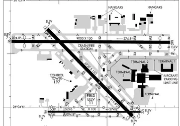
Now that FLL is a bonifide minihub, when are we gonna see a terminal map for FLL? Given that there are international customs and transit issues, it might be helpful.

Thanks
 
Another runway for airline use in FLL por favor.

The vectoring and speed controls and delays for take-off are getting ridiculous.
 
Cfm56 said:
Another runway for airline use in FLL por favor.

The vectoring and speed controls and delays for take-off are getting ridiculous.
[post="250203"][/post]​

Can commercial craft use 9R? Looks smallish, but not too small.
 

Attachments

  • FLL.webp
    FLL.webp
    41.8 KB · Views: 105
I don't have a map but I just did a pick up and drop off at FLL. FLL was very easy to get to from Interstate 95. The signage was clear and easy to follow. Short term parking was convenient to all terminals and costs $1.00 for each 1/2 hour. Long term parking is in the same parking garages but on different levels, I don't know the cost.


Jay
 
I was thinking more terminal map - a la how to move from international to the E gates.

Heck, the website still has BWI which has, what, 30 flights a day?

bwi_09_25_02.gif


and MIA, which can't have more than 40 star flights a day.

miami_lg.gif
 
there is a diagram of the fll a/p in the back of this months attache magazine. would have saved you a post if you would have looked at it.
 
Umm I havent flown this month (at least not on US). But that would be too easy for you to miss.
 
I could swear there's a map of FLL in the Attache under US Airways Key Cities.
 
Light Years said:
I could swear there's a map of FLL in the Attache under US Airways Key Cities.
[post="250294"][/post]​

There is. The maps in Attaché are all kept very up to date (which is certainly a great thing for someone on a plane looking for their next connecting gate). The maps on the website are definitely not at all up to date. Check out the website map for PIT, for example.

It should certainly be easy enough to fix. I mean, they already have the correct maps, they're printing them in Attaché.

Perhaps PineyBob or someone could pass this along to someone who could get the website maps fixed?
 
The website maps are a few years old for destinations. They still have the tan map that includes a whole smattering of cities US no longer serves.
 
Like many airports, FLL has other runways that airliners can use but the problem is noise restrictions, so there's valuable concrete not being used. Usually the airport was there long before the residents, then the residents get all in huff due to airport (airplane) noise. HELLOOOOO???.....what did you expect mving into a house near the airport? The airport authorities should not bend to desired restrictions from nearby residents -- let the airport be an airport and simply don't allow homes to be built so close or go ahead and have them built but understand it'll be noisy.
 
ringmaruf said:
Perhaps PineyBob or someone could pass this along to someone who could get the website maps fixed?
[post="250318"][/post]​


You can actually do it yourself. Just click on the contact the webmaster area on the website and tell them the maps are outdated. I've done that when I've found bad info on the site and they've corrected it within a day or two.
 
tadjr said:
You can actually do it yourself. Just click on the contact the webmaster area on the website and tell them the maps are outdated. I've done that when I've found bad info on the site and they've corrected it within a day or two.
[post="250475"][/post]​

Done. It only took me about 5 minutes to figure out how to contact the webmaster. 🙄

Now let's see how quickly they can get the new maps up, down there in El Salvador. 🙂
 

Latest posts

Back
Top